Project Update: Spreading variable rate lime on grassland at Pantyderi
Soil mapping by electrical conductivity (EC) scanning has been carried out on 40ha of grassland at Pantyderi. This process maps how soil properties vary across a field. Fields can then be subdivided into management zones on this basis. Strategic soil sampling of these zones creates a more detailed picture which can be used to manage lime and nutrient applications more precise according to zone requirements.
The diagram below shows a 6.86ha field which has been scanned and divided into four zones. Although the soil classification for the whole field is a sandy silt loam, zones A and B have soils with a higher sand content while zones C and D have a higher proportion of silt and clay.
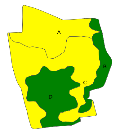
This field map is colour coded for pH, with soil sampling indicating that zones A and C require a greater lime input to bring the soil pH to the optimum for grass production at 6.3. Should the field average pH have informed flat rate lime applications, two zones would have been under applied lime while the other two zones would have been wastefully applied.
Over the 40ha of grassland that has been mapped, the use of soil mapping has identified a cost saving in lime applications using the variable rate application maps:
Rate Flat Variable
Lime tonnes 182.1 171.3
Cost £5,463 £5,139
A local lime spreading contractor with tractor and spreader GPS technology to deliver variable rate spreading was sourced. The field data was supplied to the contractor on SD card inserted into the tractor control panel to deliver the process.
Soil mapping project introduction.

1. SD card and tractor control panel

2. Tractor control panel close up

3. Spreading variable rate lime on grassland